
The Bhubaneswar Ring Road, officially the Capital Region Ring Road (Bhubaneswar Bypass), has moved past the planning stage. The Union Cabinet approved it in August 2025, and NHAI awarded all three construction contracts in March 2026 [1][3]. The new six-lane highway will run for about 111 km from Rameshwar to Tangi, taking through traffic around Khordha, Bhubaneswar and Cuttack instead of through them.
This article sets out what the government has officially said about the project: the route, cost, contractors, timeline and current status. Every figure comes from Press Information Bureau (PIB) releases, listed at the end.
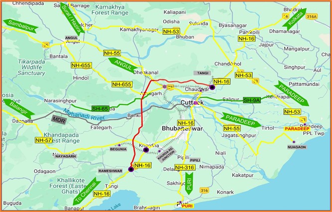
Map of the corridor. Source: Press Information Bureau, Government of India, Cabinet release of 19 August 2025 [1]. Reproduced unaltered under the PIB copyright policy.
The project at a glance
- Official name: 6-Lane Access-Controlled Capital Region Ring Road (Bhubaneswar Bypass) [1]
- Route: Rameshwar to Tangi [1]
- Length: 110.875 km, rounded to 111 km in later releases [1][3]
- Type: new six-lane "greenfield" highway (built on a fresh route, not by widening an old road), with access control: vehicles can join or leave only at interchanges [1]
- Cost: Rs 8,307.74 crore [1]
- Funding model: Hybrid Annuity Mode (HAM), in which the government pays part of the cost during construction and the rest to the contractor in instalments over the following years [1]
- Design speed: 100 km/h [3]
- Built by: National Highways Authority of India (NHAI), under the Ministry of Road Transport & Highways [2][3]
Why it is being built
According to the Cabinet release, traffic between Rameshwar and Tangi on the existing National Highway "experience[s] significant congestion" because it passes through Khordha, Bhubaneswar and Cuttack [1]. The bypass is meant to move heavy commercial traffic out of all three cities, make freight faster and cut logistics costs [1].
What it connects
- Highways: three National Highways (NH-55, NH-57 and NH-655) and one State Highway (SH-65) [1]
- Nodes: 10 economic, 4 social and 5 logistics nodes [1]
- Transport links: one major railway station, one airport, one proposed Multi-Modal Logistics Park and two major ports [1]
Who is building which stretch
NHAI issued Letters of Award for all three packages on 3 March 2026 [3]:
Package I: Rameshwar to Bilipada (40 km)
- Contractor: Patel Infrastructure Limited
- Includes: 12.4 km of service road on each side, 2 interchanges, 1 road-over-bridge, 10 minor bridges, 142 culverts, 7 elevated underpasses, 8 vehicular and pedestrian underpasses [3]
Package II: Bilipada to Gobindpur (30 km)
- Contractor: VRC Constructions (India) Limited
- Includes: 7.2 km of service road on each side, 3 interchanges, 11 minor bridges, 90 culverts, 3 elevated underpasses, 12 vehicular and pedestrian underpasses [3]
Package III: Gobindpur to Tangi, near Bandola Toll Plaza (40 km)
- Contractor: HG Infra Engineering Limited
- Includes: 10 km of service or slip road on each side, 1 interchange, 23 minor bridges, 69 culverts, 2 elevated underpasses, 25 vehicular and pedestrian underpasses [3]
Each package also includes one wayside amenity [3]. The six interchanges in total are the only points where traffic can get on or off the ring road.
Timeline and status
- 19 August 2025: Cabinet Committee on Economic Affairs approves the project [1].
- 10 February 2026: NHAI reports 64 bids across the three packages (23, 25 and 16). It says about 96% of land acquisition, along with forest, wildlife and environment clearances, is complete [2].
- 3 March 2026: Letters of Award issued for all three packages [3].
- Completion: about 30 months from the date work commences [3]. NHAI has not published a commencement date in these releases, so no official finish date exists yet.
What this means for property owners
The government releases talk about decongestion, freight and regional growth. They make no forecast about land or rent values, and neither do we. What owners can do is check the facts for their own plot:
- Is your land inside the alignment? Land for National Highways is acquired through notifications published in the Gazette of India (egazette.gov.in). Match your village and plot numbers against the notifications for this project.
- Check your record of rights. Confirm your plot details and status on the Odisha land records portal, Bhulekh.
- Note the nearest interchange. An access-controlled road is only useful from where you can join it, so being close to the alignment is not the same as being close to an entry point.
- Don't pay for "ring road frontage" on a verbal promise. Ask the seller for the plot's position on an official map and for the land-use classification before buying.
Related reading: commercial use of residential property in Bhubaneswar and Odisha's draft Rent Control Act 2026.
This article reports official government releases for general information. It is not investment or legal advice.
Sources
- Press Information Bureau, 19 Aug 2025: Cabinet approves construction of 6-Lane Access-Controlled Capital Region Ring Road (Bhubaneswar Bypass, 110.875 km) in Odisha (includes the corridor map).
- Press Information Bureau, Ministry of Road Transport & Highways, 10 Feb 2026: NHAI receives overwhelming response from bidders for Bhubaneswar Capital Region Ring Road Project.
- Press Information Bureau, Ministry of Road Transport & Highways, 3 Mar 2026: NHAI awards contract for construction of Bhubaneswar Capital Region Ring Road Project.


